 HurriMap
How to use HurriMap
HurriMap is personal hurricane decision support: the official hurricane and typhoon forecast, turned into a timeline for your place. This guide covers everything the app does, in plain language. In the app, the same help is under Menu → Help, and Menu → Help → Welcome tour replays the introduction.
Getting started
Open HurriMap and you'll see the map with every active hurricane, typhoon, invest and outlook area. A short welcome tour runs the first time; you can skip it and replay it later from Menu → Help.
1. Set My place
Most of what HurriMap tells you depends on where you are. Open Menu → My place and choose one of three ways:
- Enter a ZIP code. Quick, and doesn't need location permission. Good for storm information and alerts.
- Press and hold on the map at your home or street. This sets an exact spot.
- Use my location. HurriMap reads your location only when you tap this. It doesn't track you.
Your place shows on the map as a house marker. Your place can be your home, a family member's town or a property you look after. It doesn't have to be where you are now.
2. Pick a storm
The chips across the top list Overview and each active storm. Tap a storm to focus on it. The colored letter in each chip is its current strength (see Reading the map).
3. Pull up the panel
The panel at the bottom holds the details for whatever the map is showing. Drag it up for more and down to see more map.
4. Turn on alerts
In Menu → My place, switch on Notify me for my place and allow notifications when your phone asks. Tropical storm warning alerts are free. Add Pro and you get watch alerts too: the head start, about 48 hours before the winds. It takes ten seconds, and it's the most valuable switch in the app.
Why HurriMap alerts you to watches, not hurricane warnings
Here's something most people don't know: when a hurricane warning goes up, your phone already gets it. The government broadcasts hurricane, storm surge, tornado and extreme wind warnings straight to every phone in the area through Wireless Emergency Alerts. It's fast, it's loud, and it needs no app at all.
What your phone doesn't get is the alert that matters most for getting ready: the watch. A hurricane watch goes up about 48 hours before tropical-storm-force winds are expected. It's the starting gun, and it arrives silently. Tropical storm warnings don't get broadcast either, even though 39 to 73 mph winds are enough to bring down trees and power lines.
That's the gap HurriMap fills. Every HurriMap user gets tropical storm warning alerts for their place, free. HurriMap Pro adds the watches: the moment the National Weather Service issues a hurricane, tropical storm, storm surge or typhoon watch for your place, Pro tells you. That's two days of head start: time to fill prescriptions, gas up, bring in the patio furniture and make your decisions calmly, before the lines, the empty shelves and the traffic.
Then HurriMap keeps going where the alert stops. My place turns the forecast into your own timeline: when damaging winds could arrive at your door, and the hour to have your preparations finished.
Wireless Emergency Alerts sound the alarm. HurriMap gives you the head start. Keep both on, and you're covered from the first watch to the last warning.
And it's private by design. There's no account to create, and we never learn where you are: your phone simply follows its National Weather Service forecast zone. More in Alerts for your place.
The map
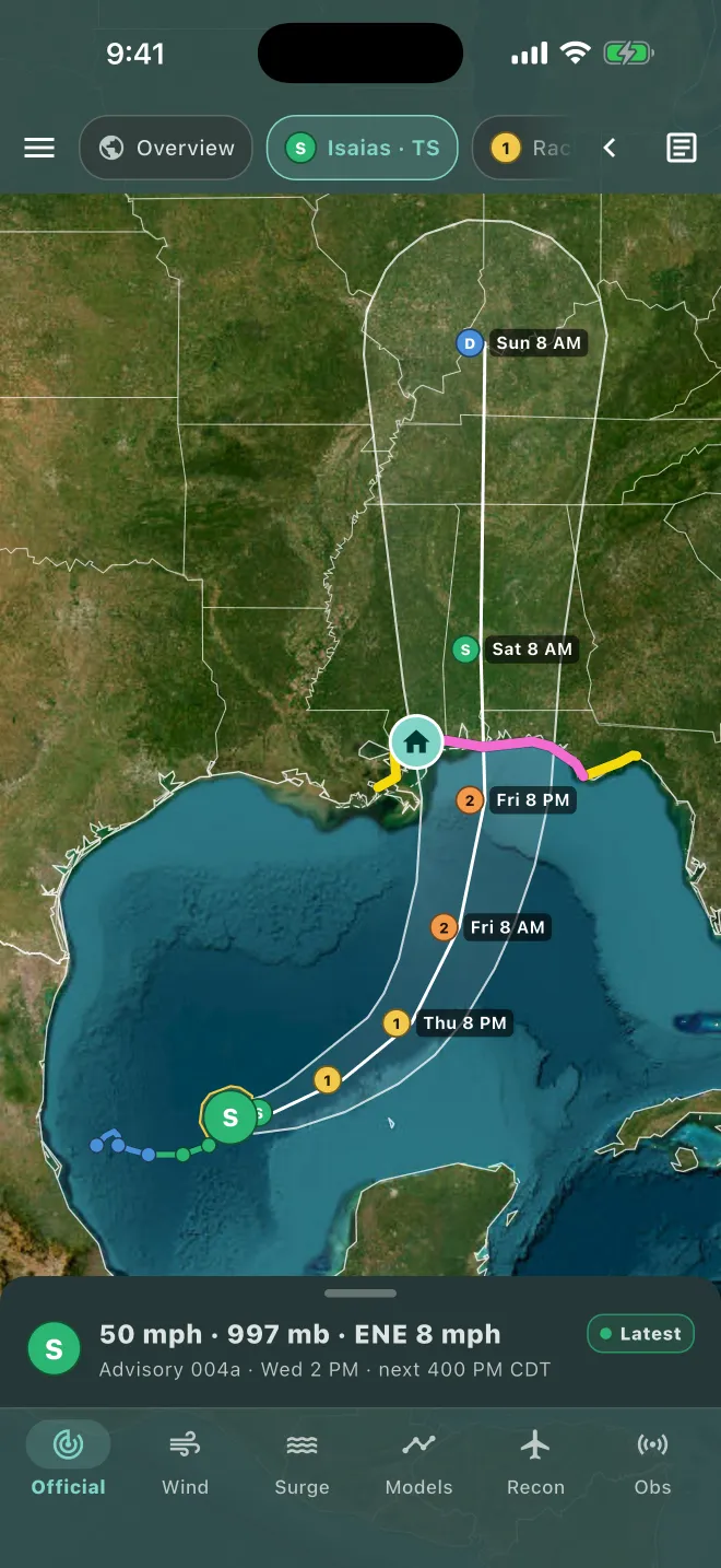
- Top bar: the menu (☰), the storm chips, the ‹ tools button, and the page button for NHC products.
- Bottom buttons (lenses): Official, Wind, Surge, Models, Recon and Obs. In landscape they run down the left side. Recon appears only when there is reconnaissance data.
- Tools (‹): opens Scenario, satellite, advisory label, share and draw. They're tucked away so the map stays clear. An advisory label pins an NHC-style box with the latest advisory (position, time, winds, movement) wherever you tap the map; it stays until you tap it and choose Delete.
- Panel: the details for the current lens. Its top line shows the advisory, when it was issued, and when the next one is due.
- Landscape: turn your phone sideways for a bigger map, with the lenses on the left and the panel on the right.
HurriMap refreshes every 5 minutes while open and whenever you come back to it. Every product shows its source and time.
Overview
Overview shows all active storms with their cones and tracks, invests (disturbances NHC is watching), and NHC's 7-day tropical weather outlook areas with their chances of development. The panel lists the storms, the outlook text for each basin (Atlantic, eastern Pacific, central Pacific) and the reconnaissance schedule. Live Hurricane Hunter aircraft also show here when flying. Typhoons and South Pacific cyclones appear alongside them; when storms span the Pacific, the map frames them across the date line.
Typhoons and the Pacific
In the Pacific, Americans face typhoons, not hurricanes. HurriMap covers both. Hurricanes in the Atlantic, Gulf, Caribbean and the eastern and central Pacific (including Hawaii) come from the National Hurricane Center. Typhoons in the western Pacific and cyclones in the South Pacific come from the Joint Typhoon Warning Center (JTWC), the forecast center for Guam, the Northern Mariana Islands and American Samoa.
Typhoons work like hurricanes in HurriMap, with a few differences worth knowing:
- Danger area instead of a cone. JTWC draws a dashed area where tropical-storm-force winds could reach, allowing for forecast error. It's wider than a cone because it includes the storm's size.
- Wind chances and arrival times. JTWC doesn't publish them, so HurriMap estimates them the way NHC makes its own: 500 versions of JTWC's forecast, each shifted by JTWC's typical track and strength errors. The Wind lens, the arrival contours and Finish preparations by all work for typhoons. HurriMap labels them as its estimate wherever they appear.
- Wind field over time. The Wind lens steps through JTWC's forecast wind radii out to 5 days.
- Models. JTWC's forecast in bold, with the European (ECMWF) model, its AI version and its ensemble members.
- JTWC products. The page button opens JTWC's warning (position, strength, movement and forecast) and its prognostic reasoning.
- Watches and warnings. The National Weather Service in Guam issues typhoon and tropical storm watches and warnings for Guam and the Northern Marianas. They show on the map and in My place, and the storm briefing lists them.
- Strength. Typhoon markers use the same colors and numbers as hurricanes, by wind speed. A super typhoon has winds of 150 mph or more.
One storm, one forecast. JTWC also tracks eastern and central Pacific hurricanes. When it does, HurriMap shows only NHC's official forecast, so you never see two versions of the same storm.
Official lens
NHC's official forecast, drawn the way NHC draws it, but live and zoomable.
- Cone: where the center of the storm will probably be. It doesn't show how big the storm is; hazards often reach well outside it.
- Track and forecast points: each point shows the time in your local time zone and the expected strength.
- Watches and warnings along the coast, in NHC's colors.
- Current wind field: how far tropical-storm and hurricane-force winds reach right now.
- Past track: where the storm has been, colored by strength.
The briefing
Pull up the panel for the briefing: maximum wind, pressure and movement, NHC's headline, key messages and hazards. If My place is set, an At my place section summarizes what the storm means there.
Advisory history
The advisory slider in the panel steps back through every earlier advisory for the storm. The Latest marker on the panel's top line tells you whether you're looking at the newest one. Stepping back shows how much a forecast can move in a few days.
Intermediate advisories (for example "004a") update the position and strength between full advisories, every 3 hours when watches or warnings are in effect.
Wind lens
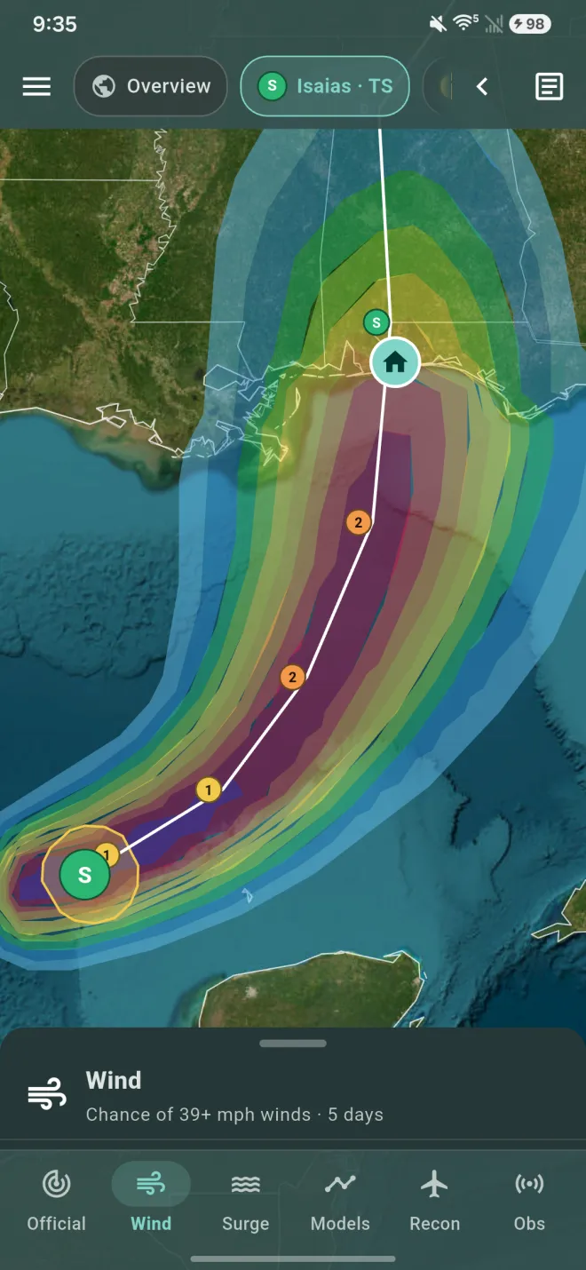
Wind probabilities
The chance of tropical-storm-force (39+ mph), strong tropical-storm (58+ mph) and hurricane-force (74+ mph) winds over the next 5 days, from NHC. Switch between the three in the panel. For typhoons, HurriMap estimates them from JTWC's forecast (see Typhoons and the Pacific).
Wind field over time
Use the time slider to see NHC's forecast wind radii at each forecast time: how far each wind speed reaches, quadrant by quadrant.
Arrival
When NHC issues them, or HurriMap estimates them for a typhoon, the Arrival view draws labeled contours of when winds could begin, in your local time:
- Earliest reasonable arrival: there's only about a 1-in-10 chance winds arrive sooner. Use this one for planning.
- Most likely arrival: the single most likely time.
The first 39 mph winds are the end of safe preparation and travel. Outdoor work and driving become dangerous once they arrive.
Surge lens
Storm surge, water pushed ashore by the storm, causes most hurricane deaths. The Surge lens shows:
- Storm surge watches and warnings issued by NHC.
- Potential storm surge flooding, in feet above ground, when NHC publishes its inundation map for a storm threatening the U.S. coast.
For whether your own spot can flood in a hurricane at all, see Storm surge risk in My place.
Scenario
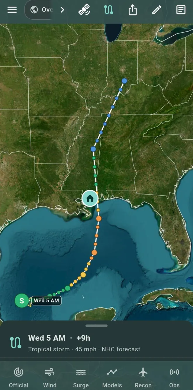
NHC's forecast is the most likely path and strength, but storms rarely follow it exactly. A scenario lets you ask "what if": what if it comes ashore 30 miles south, or arrives one category stronger? Emergency managers plan this way. Plan for a reasonable worst case, not just the forecast.
Open it from the tools button (‹) in the top bar.
Step through the forecast
Without changing anything, a scenario replays NHC's forecast in 3-hour steps. Press play or drag the time slider. The colored rings show how far tropical-storm-force (39+ mph, yellow), strong tropical-storm (58+ mph, orange) and hurricane-force (74+ mph, red) winds reach at that moment. Large dots are NHC's forecast times; the dots between them are interpolated. Stepping through is free.
Move the track Pro
- Tap a dot, then tap or drag on the map where you want that point to be.
- The track bends smoothly from the storm's current position to your point, and everything after it moves the same amount.
- To test a landfall, pick the dot nearest the coast and move it along the shore.
- Tap Done when finished. Undo this point removes that edit; Reset all returns to NHC's forecast.
Change the strength Pro
- With a dot selected, use − and + to make the storm weaker or stronger at that time (about 10 mph per tap).
- The change fades in from now to that time and holds after it.
- HurriMap adjusts the wind rings to match: a stronger storm's winds reach a bit farther, and hurricane-force winds appear or disappear as it crosses 74 mph. This is an estimate; NHC doesn't forecast every possibility.
Compare earlier forecasts
Start from replays any earlier NHC advisory for the storm, a good reminder of how much a forecast can move.
Using it to decide
- Set My place first. The scenario panel then tells you when, and how strong, winds would reach you in that scenario.
- Try the forecast, then a shift toward you, then a stronger storm. If any reasonable scenario puts hurricane-force winds or storm surge at your place, plan as if it will happen.
- Scenarios never replace evacuation orders. If officials order your zone out, go.
Models lens Pro
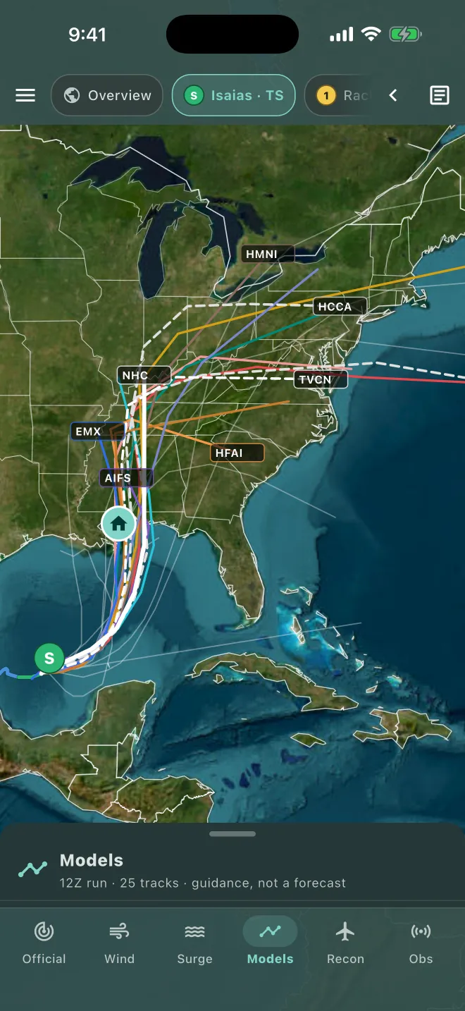
The "spaghetti" of computer model tracks that NHC forecasters look at, including the European (ECMWF) model.
- Filters: Main (the most-used models and consensus), GEFS ensemble members, ECMWF ensemble members, or All.
- Tap a model in the Tracks list to show that model alone, for example Google DeepMind. Tap All to bring back the full spaghetti.
- NHC's forecast is the bold white line; the consensus is dashed. Consensus aids are usually more reliable than any single model.
- Intensity chart: every model's forecast wind speed over time.
- The panel shows the model run time (for example "12Z run") and how many tracks are drawn.
Model tracks are guidance, not a forecast. Individual models can be far off; for decisions, use NHC's official forecast.
Recon lens Pro
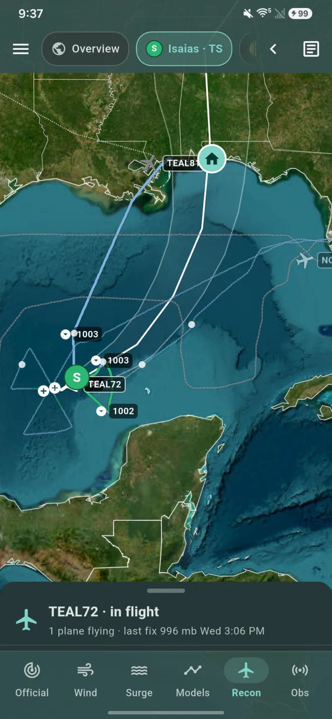
Appears when the Hurricane Hunters (NOAA and the U.S. Air Force Reserve) are flying or have flown into a storm in the last 18 hours.
- Flight tracks colored by flight-level wind, from the aircraft's high-density observations.
- Live aircraft with 8-hour trails, updated every 30 seconds.
- Dropsondes, vortex fixes (the measured center, pressure and winds) and RECCOs.
- Plan of the day: scheduled missions from NHC's reconnaissance plan.
Obs lens
NOAA buoys and coastal stations within 750 miles of the storm, from the last 3 hours: wind arrows, pressure and waves. Tap a station for wind, gusts, pressure, air and water temperature, and when it was observed.
In Menu → Layers you can switch from simple markers to station plots: temperature and dew point (°F), a wind barb (knots) and sea-level pressure (coded, in tenths of a millibar), as on a forecaster's surface map.
Why timing matters
HurriMap is a personal decision support tool. Emergency managers plan hurricanes around time, not the cone: when could tropical-storm-force winds (39+ mph) first arrive, and how long does it take to be ready? Work back from the first, subtract the second, and you have the moment a decision can't wait. HurriMap does the same calculation for your place.
The timeline for your place
- Earliest reasonable arrival of 39 mph winds: NHC's planning time, with only about a 1-in-10 chance the winds come sooner.
- Most likely arrival: when they'll probably start. Don't plan to this one; the first squalls can come hours earlier.
- Closest approach: when the center passes nearest, how far away and how strong.
- Winds easing: when tropical-storm-force winds are forecast to end.
- Finish preparations by: the earliest reasonable arrival minus your preparation time.
For example, if 39 mph winds could arrive as early as Friday at 2 PM and you need 12 hours, HurriMap says to finish by Friday at 2 AM.
Choosing your preparation time
Be honest and generous. Count everything you'd still need to do once you decide to act:
- shutters or plywood, securing outdoor furniture, boats and vehicles;
- water, food, medications, fuel and cash, when stores may already be crowded;
- helping family members, neighbors or pets, or getting them where they need to be;
- if you'll leave, the drive to your destination, which takes longer in evacuation traffic;
- sleep. A deadline at 2 AM really means finishing the evening before.
Tap Change the 12 hours on any My place card to set yours. Your watch and widget use it too.
Using it as the storm approaches
- Check after each NHC advisory (5 and 11, AM and PM Eastern). The deadline moves as the forecast changes, and it can move earlier.
- If the deadline is getting close and you're still unsure, act. Preparing for a storm that misses costs far less than being caught by one that doesn't.
- Use Scenario to see how the timeline changes if the storm tracks closer or comes in stronger.
- For family or property somewhere else, set My place there to read its timeline, then set it back.
My place
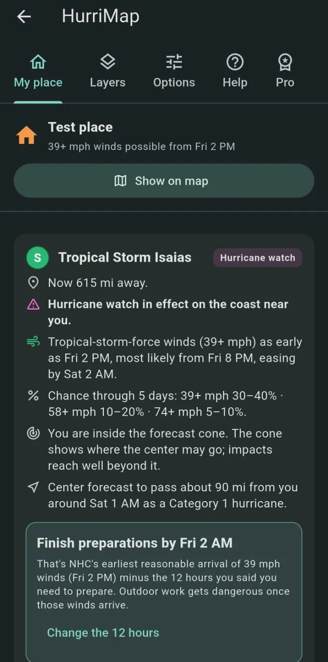
Open Menu → My place. For every active storm, HurriMap shows a situation card for your place:
- Distance from the storm's center now.
- Watches and warnings in effect on the coast near you.
- When tropical-storm-force winds could arrive (earliest reasonable and most likely) and when they're expected to ease.
- Chances through 5 days of 39, 58 and 74 mph winds.
- Whether you're inside the cone, and how close the center is forecast to pass, when, and at what strength.
Show on map jumps to your place.
Finish preparations by
The earliest reasonable arrival of 39 mph winds (NHC's for hurricanes, HurriMap's estimate from JTWC's forecast for typhoons), minus the hours you say you need to finish preparing (12 by default; tap Change the 12 hours). Outdoor work gets dangerous once those winds arrive, so this is your deadline for shutters, supplies and securing outdoor things. It's a planning aid built from the official forecast, not an evacuation order.
Alerts for your place
Active NWS watches, warnings and statements that include your place, newest first, with the issuing office and expiry time. Tap one for the full text.
Your local NWS office
When a storm threatens, the National Weather Service office for your area issues a Hurricane Local Statement with its own headlines and preparedness actions. My place shows it word for word, credited to the office, with the full text a tap away.
Storm surge risk
NHC's National Storm Surge Risk Maps for your spot: the worst-case surge flooding in a Category 1 to 5 hurricane. It tells you whether you live in surge country. It is not a forecast; when a storm threatens, watch for NHC storm surge watches and warnings.
Evacuation zones and orders
In Florida, HurriMap shows your evacuation zone and your county's current evacuation, curfew and re-entry status. Elsewhere, check your county or parish emergency management website for your zone.
Open shelters
Open shelters within 150 miles, with pet-friendly and accessibility information, occupancy, and one-tap directions in your phone's maps app. Counties open shelters as a storm approaches, sometimes on short notice. Shelters are a last resort; friends or family outside the evacuation zone, tens of miles away rather than hundreds, are usually better.
NOAA Weather Radio
The NOAA Weather Radio transmitters for your county. Any radio that tunes the VHF weather band (162.400 to 162.550 MHz) can receive them when in range, and they keep working when cell networks fail. Radios with SAME alerting can be set to your county's code, shown here, so they only sound for you.
Run from water, hide from wind
Evacuations are mainly for storm surge. Most people outside the surge zone can ride out the wind in a sturdy building, in an interior room away from windows.
HurriMap only talks about leaving when your place is inside an NHC storm surge watch or warning, or when an evacuation order is reported. Even then, getting out of the surge zone is what matters, often only a few miles inland. If you live in a mobile or manufactured home, a high-rise, or a place vulnerable to high wind, follow your local officials' advice on sheltering elsewhere.
HurriMap will never tell you that you don't need to evacuate. Always follow your local officials; if ordered to evacuate, go.
Alerts for your place
Your phone already gets Wireless Emergency Alerts (WEA) for the most urgent warnings: hurricane, typhoon, storm surge, tornado and extreme wind warnings, and the most serious flash flood warnings. They're broadcast to every phone in the area, with no app in between.
WEA doesn't send watches or tropical storm warnings, the alerts that start the clock on getting ready. HurriMap fills that gap, and you hear about them for your place as soon as the National Weather Service issues them:
| Alert | Included with |
|---|---|
| Tropical storm warning | Free |
| Hurricane watch | Pro |
| Tropical storm watch | Pro |
| Storm surge watch | Pro |
| Typhoon watch (Guam and the Northern Mariana Islands) | Pro |
What a watch means
A watch means dangerous conditions are possible in your area, usually within 48 hours. It's time to get ready: review your plan, check supplies, and know your evacuation zone and route. A storm surge watch means life-threatening flooding from rising water is possible.
A warning means the conditions are expected, usually within 36 hours, so finish preparing. A tropical storm warning means winds of 39 to 73 mph are expected.
Watches are your head start, a heads-up to prepare while there's still time. The urgent, act-now warnings come to your phone through Wireless Emergency Alerts. Keep both on, and nothing about the storm catches you off guard.
Turning alerts on
- Set My place. A ZIP code is enough.
- In Menu → My place, switch on Notify me for my place.
- Allow notifications when your phone asks. It shows On for your place when it's ready.
- For watch alerts, tap Add watch alerts with Pro, or subscribe in Menu → Pro. Watches start automatically, and My place shows including watches.
Alerts follow your place's National Weather Service forecast zone, and each one arrives once. Updates to the same watch don't notify you again; an upgrade from a watch to a warning does.
Tornado warnings on the map
Hurricanes often spawn tornadoes, especially in their outer bands. Active tornado warnings show on the map in red (magenta for a tornado emergency); tap one for details. Wireless Emergency Alerts deliver them to your phone.
Turning alerts off
Switch them off in My place, or remove your place. HurriMap's server never receives your place: your phone follows its forecast zone through Apple and Google's notification services. See the privacy policy.
NHC products
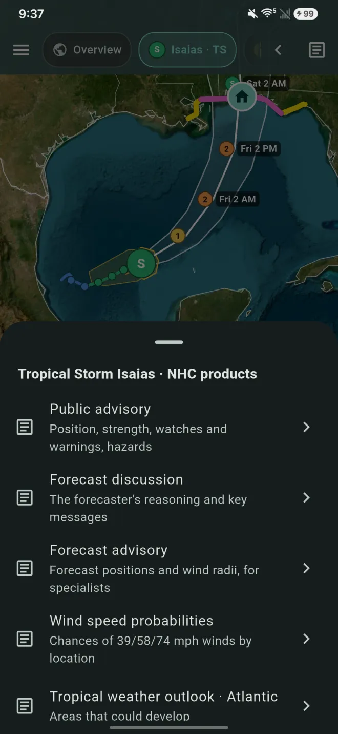
The page button at the top right opens NHC's text products for the selected storm, reflowed to fit your screen:
- Public advisory: position, strength, watches and warnings, hazards.
- Forecast discussion: the forecaster's reasoning and key messages.
- Forecast advisory: forecast positions and wind radii, for specialists.
- Wind speed probabilities: chances of 39/58/74 mph winds by location.
- Tropical weather outlooks and the reconnaissance plan of the day.
For a typhoon, the same button opens JTWC's warning and prognostic reasoning.
The buttons at the top switch between reflowed text and NHC's original layout, and copy the text.
Layers and satellite
The layers button on the map, or Menu → Layers, sets:
- Base map: gray canvas (the default, easiest to read), street, satellite or hybrid.
- Weather satellite (GOES): none, infrared, clean longwave IR (band 13, in the enhanced colors forecasters use for cloud-top temperature), visible or water vapor, drawn under the storm graphics with coastlines and borders on top. Imagery updates every 5 to 10 minutes over most of the Atlantic and eastern Pacific.
- Storm map (Official view): cone, track, labels, watches and warnings, current wind field, past track and wind history. Reset storm map to defaults puts it back to NHC's style.
- Observations (Obs view): simple markers or station plots.
The satellite button in the tools (‹) turns imagery on and off quickly.
Options
Menu → Options holds:
- Appearance: match system, light or dark.
- App icon: HurriMap, Hurricane flags or Radar.
- Home-screen widget: how to add it (see below).
Home-screen widgets
The widget shows the storm that matters most for My place, and what it means there, without opening the app. Set My place first.
- iPhone and iPad: touch and hold your Home Screen, tap Edit, then Add Widget, and search for HurriMap.
- Android: tap Add widget to home screen in Menu → Options. If your launcher doesn't support that, touch and hold your home screen, tap Widgets, and find HurriMap.
Apple Watch and Wear OS Pro
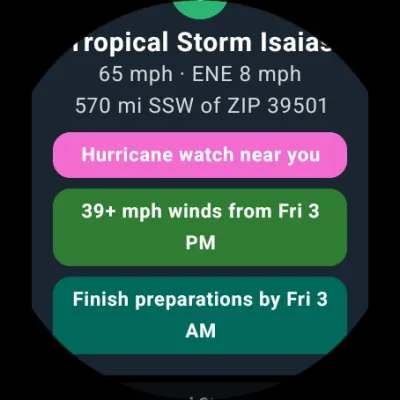
The watch app shows, for My place: the nearest storm, its distance and direction, whether you're in the cone or near a watch or warning, when tropical-storm winds could arrive, the closest approach, and when to finish preparing. Scroll for other active storms.
The watch downloads the storm data itself, so it stays current even when your phone is out of reach, as long as the watch has a connection.
Setting it up
- Apple Watch (watchOS 10 or later): install HurriMap on the watch from the Watch app on your iPhone (or the App Store on the watch). Add a HurriMap complication to your watch face for a quick look.
- Wear OS (Wear OS 3 or later): install HurriMap from Google Play on the watch. Add the HurriMap tile, or the complication to your watch face.
Your place, the hours you need to prepare and your Pro status are sent from the phone automatically. Open HurriMap on the phone once after changing them if the watch hasn't caught up.
HurriMap Pro
Forecasts, watches and warnings, storm surge, wind arrival times, NHC advisories, tropical storm warning alerts and My place are always free. Pro adds watch alerts, the Models and Recon lenses, scenario editing, drawing on maps and the watch app.
Subscribing
Open Menu → Pro and choose monthly or yearly. Payment is handled by the App Store or Google Play. Pro works on every device signed in to the same store account.
Restoring Pro on a new phone
Sign in with the same Apple ID or Google account, open Menu → Pro and tap Restore purchases.
Cancelling
- iPhone and iPad: Settings → your name → Subscriptions → HurriMap.
- Android: Google Play → your profile icon → Payments & subscriptions → Subscriptions → HurriMap.
Pro stays on until the end of the period you've paid for. Deleting the app doesn't cancel a subscription.
Reading the map
Storm strength
Storm markers and past tracks use these colors, with the letter or number showing the type:
- D Tropical depression (under 39 mph)
- S Tropical storm (39–73 mph)
- 1 Category 1 (74–95 mph)
- 2 Category 2 (96–110 mph)
- 3 Category 3 (111–129 mph)
- 4 Category 4 (130–156 mph)
- 5 Category 5 (157+ mph)
- L Invest, low or remnant
Categories 3 to 5 are major hurricanes. Typhoons and South Pacific cyclones use the same colors and numbers, by wind speed.
Watches and warnings
- Hurricane or typhoon warning
- Hurricane or typhoon watch
- Tropical storm warning
- Tropical storm watch
- Storm surge warning
- Storm surge watch
- Tornado warning
- Tornado emergency
- Flash flood warning
A watch means the conditions are possible, usually within 48 hours. A warning means they're expected, usually within 36 hours. Finish preparing when a warning is issued.
Glossary
- Advisory
- NHC's official forecast package, issued every 6 hours (5 and 11, AM and PM Eastern) with intermediate updates every 3 hours when watches or warnings are in effect.
- Cone
- The probable path of the storm's center, based on NHC's past forecast errors. About two-thirds of the time the center stays inside it. It says nothing about the storm's size.
- Earliest reasonable arrival
- The time before which there's only about a 10% chance tropical-storm-force winds arrive. Use it for planning.
- Most likely arrival
- The single most likely time for winds to arrive.
- Invest
- A weather system NHC is investigating for possible development, numbered 90–99 with a basin letter (for example 92L).
- Potential tropical cyclone
- A system that isn't a tropical cyclone yet but is expected to bring tropical-storm or hurricane conditions to land within 48 hours, so NHC issues advisories and warnings for it.
- Storm surge
- An abnormal rise of water pushed ashore by a storm, above the normal tide. It causes most hurricane deaths.
- Wind speed probabilities
- The chance that a location sees winds of at least 39, 58 or 74 mph over a period, accounting for uncertainty in track, strength and size.
- Typhoon
- A hurricane in the western North Pacific, west of the date line. A super typhoon has winds of 150 mph or more. In the South Pacific the same storms are called tropical cyclones.
- JTWC
- The Joint Typhoon Warning Center in Pearl Harbor, Hawaii, which forecasts typhoons and South Pacific cyclones. Its forecasts come out as numbered warnings, the Pacific counterpart of NHC's advisories, every 6 hours in the western Pacific and every 12 in the South Pacific.
- Danger area
- JTWC's dashed outline of where tropical-storm-force winds could reach, allowing for forecast error.
- Spaghetti models
- Forecast tracks from individual computer models. Guidance for forecasters, not a forecast.
- Ensemble
- Many runs of the same model with slightly different starting conditions (GEFS from NOAA, ECMWF ensemble from Europe), showing the range of possibilities.
- Consensus
- An average of several models, usually more accurate than any single model.
- Vortex fix
- A Hurricane Hunter measurement of the storm's center: position, minimum pressure and winds.
- Dropsonde
- An instrument dropped from an aircraft that measures wind, pressure, temperature and humidity on the way down to the sea.
- Z (UTC)
- Coordinated Universal Time, used for model runs. 12Z is 8 AM EDT; 00Z is 8 PM EDT the previous day.
- Knots
- Nautical miles per hour, used by forecasters. 1 knot is about 1.15 mph.
- SAME code
- A six-digit county code you program into a weather radio so it sounds only for warnings in your county.
Still stuck? See Support for common questions, or contact us.